

To provide information about potentially hazardous conditions associated with the eruption of the Icelandic volcano Grindavik; FORCE (Forecasting Operations for Research Campaigns and Experiments) based at the National Centre for Atmospheric Science (NCAS) are running simulations using the Weather Research and Forecasting (WRF) model and the HYSPLIT model.
HYSPLIT
The HYSPLIT system uses numerical weather forecast data to predict the transport, dispersion and deposition of airborne materials (in this case volcanic ash). HYSPLIT works by combining a Lagrangian approach for advection and diffusion and an Eulerian, grid based methodology to compute concentrations. The result, when combined with the physical properties of the airborne contaminant (particle size and density), the location of the volcanic source, the volcanic plume height and the eruption duration, is the ability to indicate where in the atmosphere the greatest concentrations will be and where the ash will be deposited. This information is a valuable tool to indicate the predicted areas of risk, and allow mitigating action to be taken where appropriate (e.g. diversion of flights) While eruptions are predicted, but have not yet happened, the FORCE HYSPLIT simulations assume an eruption start time of 12 UTC and 3 different plume heights (5, 10 and 15 km above ground level) to give a range of possible dispersion patterns. Eruption rates are based on the Sparks-Mastin relation. Simulations are 36 hours long and are initialised daily using NCEP GFS forecasts. The horizontal grid resolution is 0.2°✕0.2°. Ash concentration images are generated as 1 hour average values (every 6 hours) at 9 separate altitudes (listed below). All HYSPLIT plots are generated using the British Geological Survey ash-model-plotting software. Level specific Images indicate the average concentration between the altitude given and the previous level. Tracked particles are emitted above the emission location up to the appropriate plume height for a given simulation. Particles have a set density of 2500 kg/m³ and can be 1 of 4 different sizes (0.6, 2, 6 or 20 microns) and are treated as spherical. The mass distribution by particle size is indicated in the table below. For full details of the HYSPLIT configuration see here.
| Concentration heights |
|---|
| 1524 m ~ 5 kft |
| 3048 m ~ 10kft |
| 4572 m ~ 15 kft |
| 6096 m ~ 20 kft |
| 7620 m ~ 25 kft |
| 10668 m ~35 kft |
| 15240 m ~50 kft |
| 30000 m ~ 98 kft |
| Particle diameter (microns) | Mass fraction |
|---|---|
| 0.6 | 0.008 |
| 2 | 0.067 |
| 6 | 0.257 |
| 20 | 0.668 |
WRF
The Weather Research and Forecasting - Advanced Research WRF (WRF-ARW) model, run by FORCE, is used to produce routine forecasts for Iceland. WRF is a numerical weather prediction model designed to be used for both atmospheric research and operational forecasting. Simulations are run once a day with initialisation data and boundary conditions from 00 UTC NCEP GFS forecasts, these data have a horizontal resolution of 0.25°✕0.25°. WRF simulations are run for a period of 72 hours with forecast variables being output hourly. A wide range of forecasting product images are generated from the WRF output variables. These can be found in the FORCE WRF catalogue and include maps, cross sections and vertical profiles.
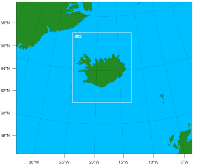
For the Icelandic FORCE simulations 2 domains have been created. The external domain (120x105 grid points) has a horizontal grid resolution of 15 km and is centred at 64.3°N, 18.3°E. The inner nested domain (201x241) has a horizontal resolution of 3 km and is positioned over Iceland (see image below). All domains have 50 vertical levels and are on a Lambert-Conformal projection to minimise grid distortion. Key physics options for the simulations are provided in the table below.
| mp_physics Microphysics option |
10 Morrison double moment scheme |
| cu_physics Cumulus physics option |
1 (domain 1) Kain-Fritsch 0 (domain 2) scheme switched off ‘convection permitting’ |
| bl_pbl_physics Planetary boundary layer physics option |
2 MYJ (Eta) TKE |
| sf_sfclay_physics Surface layer physics option |
2 Monin-Obukhov |
| sf_surface_physics Land surface physics option |
2 Unified Noah |
| ra_sw_physics & ra_lw_physics Shortwave and Longwave physics options |
1 & 1 Rapid Radiative Transfer Model |