

High-Resolution Weather Forecasting with FORCE
Force specialise in providing high-resolution weather forecasts to support research campaigns and operational planning. Central to our forecasting capability is the use of the Weather Research and Forecasting (WRF) model, one of the most advanced numerical weather prediction tools available today.
What is WRF and why do we use it?
The Weather Research and Forecasting (WRF) model is a state-of-the-art numerical weather prediction system developed in the USA. It is one of the world’s most widely used atmospheric models, with over 57,000 registered users in more than 160 countries as of 2021. In the UK alone, over 1,000 users were registered in 2023, reflecting WRF’s global prominence.
WRF is a versatile tool that supports studies across a wide range of scales, from global climate research to regional weather forecasting and high-resolution local events. Its flexibility, accuracy, and extensive user community make it an invaluable resource for advancing atmospheric science.
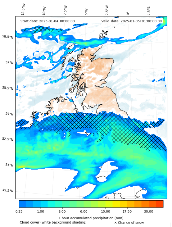
Caption: FORCE forecast for 5th January 2025, 1UTC, showing a frontal system moving north over the UK, bringing widespread snow.
Why We Use WRF Over Alternative Models
FORCE have chosen the Weather Research and Forecasting (WRF) model as our primary numerical weather prediction tool. With over 15 years of experience using WRF, our team has developed extensive expertise in running, optimizing, and interpreting model outputs for a wide range of research and operational applications. While several weather models exist, WRF offers a unique combination of flexibility, accuracy, and computational efficiency, making it particularly well-suited for our forecasting needs.
Key Reasons for Choosing WRF
- High Resolution for Regional Forecasting
Unlike global models, which operate at coarser resolutions (often 10–50 km), WRF allows us to zoom in on areas of interest using a technique called nesting. This enables us to produce high-resolution forecasts at scales as fine as 1 km, capturing small-scale atmospheric processes such as localized convection, severe storms, and orographic effects.
- Customizable and Adaptable
WRF is an open-source model with a modular framework, allowing researchers to tailor its physics schemes, dynamics, and data assimilation methods to specific forecasting challenges. Over the past 15 years, our team has developed deep expertise in customizing WRF to optimize forecasts for different research campaigns, whether for tropical cyclone tracking, convective rainfall prediction, or extreme weather events.
- Advanced Visualization Tools for WRF
At FORCE, we don’t just run the Weather Research and Forecasting (WRF) model—we ensure that its output is accessible and interpretable for both experts and non-experts. To achieve this, we have developed a comprehensive suite of visualization tools designed to present WRF forecast data in a clear and insightful way.
Initialisation of WRF Forecasts
To produce a weather forecast, models like WRF must first be initialised, which involves setting the starting conditions (known as boundary conditions) that describe the current state of the atmosphere. These conditions serve as the model's “best guess” for the atmosphere at a given time. Boundary conditions typically come from a parent global model, such as the National Center for Environmental Prediction’s Global Forecast System (GFS). GFS provides data at four key intervals each day: 00 UTC, 06 UTC, 12 UTC, and 18 UTC. In the FORCE group, WRF is used in a regional setting, where the model zooms in on a specific area of interest. This is achieved through a process called nesting, which involves solving the model equations across multiple domains with increasing resolution. The example below illustrates thenested domains used in FORCE’s forecasts for the UK.
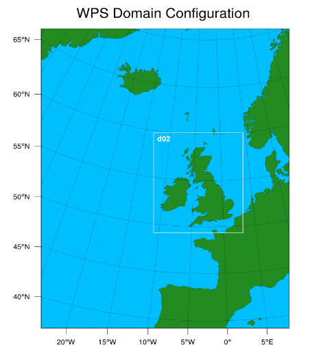
Caption: the outer domain and the second, nested, inner domain (labelled d02) for the FORCE UK runs. The resolution (distance between gridpoints in the model framework) on the outer domain is 20 km and the resolution on the inner domain is 4 km.
High-Resolution Forecasting By utilizing nested domains, WRF allows us to focus on high-resolution, localized phenomena, such as severe storms or precipitation events, while still accounting for the larger-scale weather systems. This approach ensures that our forecasts are both precise and scientifically robust, providing valuable insights for research campaigns and decision-making processes.