

Overview of the TADI Facility and Research Flights
The TotalEnergies Anomalies Detection Initiatives (TADI) facility is located in Southern France near the town of Pau. It is a research facility run by Total Energies aimed at understanding the emission of gases from industrial sites (including oil and gas facilities). There are a large number of surface instruments to measure the local meteorology and gas concentrations at the surface when experiments have taken place. In June 2024 a gas release experiment was planned and 2 coincident FAAM research flights were planned to measure the resultant gas plume (one morning flight and one afternoon flight). In order for a measurable plume (from the aircraft) to be created certain meteorological conditions had to be met. This was controlled partly by the near surface mixing (driven by the wind), the absence of rainfall but also the wind direction. The wind direction was important as the airspace in the region is controlled by the French military and westerly winds would push the plume away from the busiest airspace for military exercises.
Meteorological Conditions for Research Flight Success
The required conditions for a successful research flight were broadly westerly wind direction with near surface wind speeds in excess of 5 m/s. Clear skies were preferable with no rain and no low cloud being a requirement. Conditions other than this would lead to complications in measuring the gas plume from the FAAM research platform and would make the calculation of fluxes from the resultant data impossible. Therefore, without the required meteorological conditions there would be little scientific value in the relocation of the FAAM aircraft to perform the research flights and significant amounts of money would be wasted and carbon emitted for little to no scientific gain.
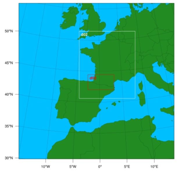
Map indicating the position of the 3 WRF domains. The outer boundary of the whole map shows the region covered by domain 1 (20.10 km grid spaced) while domain 2 (4.02 km grid spaced) and domain 3 (1.34 km grid spaced) are shown in white and red respectively.
Role of FORCE in Flight Planning and Forecasting
The Forecasting Operations for Research Campaigns and Experiments (FORCE) team was approached by Stéphane Bauguitte (FAAM) to produce forecasts to help in making a go/no go decision and in flight planning if conditions were predicted to be suitable. The timing of the planned morning and afternoon research flights necessitated the relocation of the FAAM research aircraft to the Pau-Pyrenees Airport 1 day ahead of the planned flights. Therefore in order to make the go or no go decision for the FAAM flights there was a need for forecasts to be produced with sufficient lead time to make a decision about whether or not to relocate the FAAM aircraft to southern France.
WRF Simulation Setup and Execution
Simulations were conducted using the Weather Research and Forecasting (WRF) model with 3 nested domains (see figure 1). Domains 1, 2 and 3 had horizontal grid spacings of 20.10 km, 4.02 km and 1.34 km respectively. The model grid was produced on a Lambert-conformal projection with a standard longitude of -0.65 E and true latitudes of 48.41 N and 38.41 N to minimise grid distortion over the simulated region. The number of model levels was increased to 70 compared to the usual 50 model level used for the routine FORCE WRF simulations for the UK, Iceland and Cape Verde. This increased vertical resolution provided greater boundary layer detail for the identification of the top of the boundary layer and the identification of near surface wind conditions. The initialisation and boundary conditions were provided by the Global Forecast System (GFS) 0.25°x0.25° forecast data.
Simulation Execution and Imagery Production
The WRF simulations were initialised at 16:30 UTC using data from the 12:00 UTC initialised GFS simulation and run for a total of 96 hours. Plotting of imagery was performed in parallel to the simulations so that as hourly output files from the WRF simulation became available they were post-processed to create images. The majority of images were the same type as routinely generated by FORCE, however, there was also scope for customisation and the creation of bespoke plots to allow for important features to be highlighted in the output images. Simulations took 12-14 hours to complete (this is longer than usual FORCE simulations due to the increased number of model levels and length of the simulations) meaning that a full suite of forecast imagery was available in the morning ready for decision making and planning meetings. The length of simulations (and the initialisation time chosen) meant that on a morning when planning meetings would take place there would be forecast imagery available for the rest of the current day plus an additional 2 and half days into the future. This meant that the transit flight from the UK to southern France and the period of the research flights was covered in its entirety on the day of the go/no go decision meeting. Imagery was made available (as soon as it was created) via a catalogue web page. A contingency (which was used due to Jasmin downtime) was also created where imagery was made available through a Google drive.
Supplementing WRF with External Forecasts
To augment the WRF simulations, forecast data available via Windy.com was also used to help establish the likelihood of the weather predicted in the forecast. The data available from Windy.com included simulations from a variety of national weather services with a variety of lead times and horizontal resolutions. No simulations of a comparable horizontal resolution were available for such a long lead time so the WRF simulations were a valuable addition. The forecast provided by FORCE and those that covered the appropriate time frame from Windy.com all showed good agreement on the important metrics outlined above as to whether a research flight should be conducted. While the forecasts agreed that the wind direction was good, the wind speeds were much too weak to produce a well structured (and therefore easy to measure plume). There was also a significant chance of precipitation and low cloud occurring for at least one of the planned flights. It was therefore decided that the transit of the FAAM aircraft and the research flights should be cancelled. The conditions on the day proposed for the research flights was well predicted and was actually slightly worse than had been expected. Therefore the c ancellation of the flights was the correct decision. The financial and carbon cost of having attempted to conduct flights of this type when there was little chance of making usable measurements would have been very high for almost no scientific value. Instead it has been proposed that flights be attempted in the future (September 2024) when a similar gas release experiment will be conducted at the TADI facility. Due to the very limited time frame for airborne measurements to be made in this circumstance it is expected that there will be another process of generating forecast simulations for the proposed flights in September in the hope that conditions will be favourable. In the future it might be that planning of this type will help to ensure that research flights will be impactful and that flights will not be undertaken when simulations indicate unfavourable meteorological conditions.